Sikkim Mountains & Rivers
Sikkim is a small state in the mountains of North East India. The state on the map looks like a vertical rectangle with an average width of about 70kms and an average north-south length of around 110kms. Three sides of Sikkim (North, West and East) are lined with Himalayan snow peaks while the southern side has smaller mountains through which the river Teesta finds its way down to the lower plains of West Bengal. Sikkim's terrain is mostly mountainous and is practically devoid of any large expanses of plain lands.
Although the Himalayan range stretches for about 2,500kms from Kashmir on the west all the way up to Arunachal Pradesh on the east, only about 60kms of this mountain range borders the northern boundary of Sikkim. On the other side of this border is Tibet (of China). There are two peaks at two ends of this part of the range. On the western end of Sikkim's north border is the Jongsong Peak (24,482 ft) and on the eastern end is the Pauhunri peak (23,386 ft).
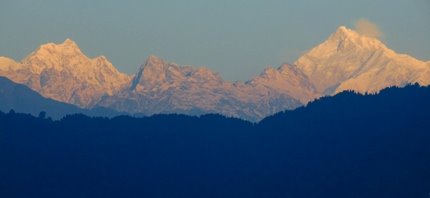
These two peaks are some what like junctions of ridges. From Jongson peak the main ridge extends west towards Mt. Everest, while another ridge known as Singalila Ridge comes down towards south and serves as the Western border of Sikkim. On the other side of this western border is Nepal. The towering Mt. Kanchenjunga, the third highest peak in the world (28,169 ft) is located on the northern section of Singalila Ridge.
Kanchenjunga from Gangtok
At the eastern end of Sikkim's north border, the main Himalayan ridge from Pauhunri extends to east towards Chamolhori peak, while another ridge (known as
Chola Ridge) comes down southwards forming the eastern border of Sikkim. On the other side of Chola ridge is the Chumbi valley of Tibet. There are several famous high altitude passes on Chola ridge such as
Nathula Pass, Jelepla Pass etc that connect Sikkim of India with Tibet of China (these are international borders and protected areas). Being surrounded by ridges on three sides, Sikkim shares its southern border mainly with West Bengal and partially with Bhutan.
Singalila Ridge is one of the most fascinating ridges in the world although it is only 150kms long. In its northern part lies Kanchenjunga with a series of peaks on its two sides including Jongsong, Tent, Twin, Talung, Kabru (all with altitude of over 24,000ft), and Pyramid, Nepal and Rathong peaks over 23,000ft. And there are snow covered Kokthang and Kang peaks that stand next to each other.
The southern part of Singalila Ridge comes down and meets the lower plains near the river Mechi. The famous
trekking trail to Tonglu, Sanfakphu, Phalut lies on this southern part of the ridge. Although the trail up to Phalut is mostly part of West Bengal and Nepal but it connects to Sikkim through Singalila Pass on the ridge. While there are no snow peaks on this part of the ridge, you can get magnificent views of the northern snow peaks from the trail. Southern section of the ridge is full of exotic Himalayan wildlife and vegetation.
Singalila ridge stretches almost vertically north to south and defines Sikkim's border with Nepal as well as with Darjeeling district of West Bengal. Almost three-fourth of the ridge area in India is reserved forest that comprises of two adjacent reserves in Sikkim... Kanchenjunga Biosphere Reserve and Varsey Rhododendron Sanctuary, and one in West Bengal...
Singalila National Park.
There are three ridges that originate from the Singalila Ridge. One goes towards west to Nepal. Over this lies the peaks of Kangbachen and Kumbhakarna... you can see them clearly from Darjeeling. The second one originates from the northern end of Kanchenjunga extending straight towards east and over this lie the peaks of Shimbho and Siniolchu (both over 22,000ft). The third ridge originates from Kabru (south of Kanchenjunga) and extends south-east... over this lie the peaks of Kabru Dome, Goecha, Narsing, Pandim, Malong etc.
The last two ridges both finally end near the
River Teesta. Teesa originates from Cholamu lake of Northern Himalayas and divides Sikkim into two parts as it flows north to south before entering Darjeeling district of West Bengal. The two parts of Sikkim are unequal in size. The western part is wider and larger while the eastern part is narrower and smaller.
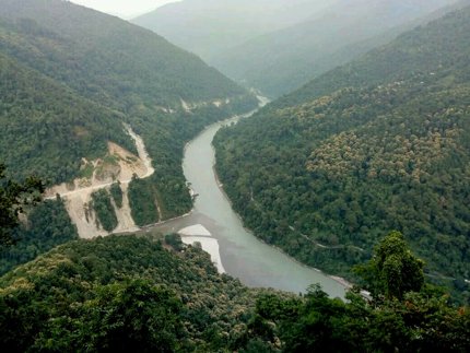
In the western part of Sikkim and north of the ridge of Shimbho/Siniolchu lies the Lhonak river valley (Lhonak is a tributary of Teesta). The Tolung river valley is located between south of this ridge and north of the ridge of Kabru Dome, Mt. Pandim etc. And further south and below the ridge of Mt. Pandim and north of West Bengal lies the Rangeet river valley. The Rangeet river too flows north-south like Teesta. The Rammam river merges with Rangeet in Jorthang of Sikkim. Finally Rangeet meets Teesta at Teesta Bazar area... this confluence of Teesta and Rangeet is a picturesque spot and known as Triveni. Read
Teesta Rangeet Confluence for details.
Triveni: Confluence of Teesta and Rangeet rivers
Now about the rivers of the eastern and smaller part of Sikkim. A main river in the southern area of this part is Rangpo Chu (chu means river in Nepali). Rangpo Chu originates near Chola ridge and finally meets Teesta river. It is this river which you can see when you go past Rangpo check post along National Highway NH10 to enter east Sikkim. The valley of Rangpo Chu is fairly large. At the northern end of East Sikkim lies the Lachung River and its valley. In north Sikkim and to the east of river Teesta there is a north-south ridge which has three mountains on it... Gurudongmar, Kanchenjhau and Chungukhang. Between this ridge and Chola ridge lies the arrow valley of Lachung river. This is where lies the
picturesque valley of Yumthang.
Related Articles
|
Visitors' Reviews/Comments
|